Yeerongpilly, a residential and industrial suburb on a railway junction, is 7 km south of central Brisbane. It is thought that the name was derived from an Aboriginal expression denoting water, perhaps a reference to the water holes on the Moolabin Creek or to the Brisbane River.
The earliest place of settlement was Rocky Water Holes (Rocklea) where the Crown Inn and a Primitive Methodist church were opened in 1862 and 1863. The district had been extensively denuded of native pine timber by the end of the 1850s, and mixed farming took its place, starting from the fertile Oxley Creek Valley and its Moolabin Creek tributary. In 1867 the Yeerongpilly provisional school was opened.
In 1875 the Brisbane to Ipswich railway line, passing through Yeerongpilly, was opened. Upon the introduction of rural local government to Queensland in 1879 the Yeerongpilly division was formed, a large rural area extending from South Brisbane to the Logan River and from Logan Road to Goodna and Greenbank in the west. As scattered settlement spread from Brisbane, parts of Yeerongpilly division were severed: the Stephens Shire (from South Brisbane to Rocklea) and the Sherwood Shire (west of Blunder Creek to Wacol) were created in 1886 and 1891. That left an entirely rural Yeerongpilly division, with the future suburb of Yeerongpilly in Stephens Shire. The divisions area was 450 sq km.
The division's offices were in Rocky Water Holes (Rocklea) which, according to the Australian handbook in 1904, might 'be considered the metropolis of the division of Yeerongpilly ... (with) two public houses, Primitive Methodist church, Presbyterian meeting house ... and blacksmith's and other shops'. Some of the downstream water holes were enclosed by the Brisbane Golf Club's course when it was laid out in 1904. (The golf course is west of the railway line, and is in the present suburb of Yeerongpilly.)
The division's southern rural part was crossed by the South Coast railway, extended from the Yeerongpilly rail junction in 1884. Dairy produce was conveyed to the Kingston butter factory (Logan), but even in the 1920s the Shire authorities thought that upwards of 30,000 acres of unoccupied land awaited the attention of orchardists and market gardeners. The Rocklea Agriculture and Industries Association Showground on Ipswich Road, a short way from the railway station, ensured them of an exhibition venue.
Yeerongpilly Shire, extending north from approximately the present-day Logan Motorway to Tarragindi, was incorporated into the greater Brisbane Council in 1925. Its census populations were 1313 (1911) and 3263 (1921).
The Yeerongpilly suburb was snugly positioned north of the Clapham railway transshipping depot, created to service the uniform railway gauge line (1930) from the border to South Brisbane. Increasing industrialisation to its south came with the Evans Deakin engineering workshops, the Archerfield Brisbane Airport (1931) and war time industry around Rocklea.
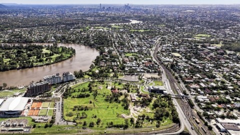
Yeerongpilly's main industries were an animal research institute and a power station, each next to the Brisbane River. The research station (1909) had several buildings listed on the Queensland heritage register and was decommissioned in 2010. The power station was in Tennyson, and the site was reserved for the Queensland Tennis Centre completed in 2009. Yeerongpilly is industrial near the railway and residential in the north.
FLOODS 2011
In January 2011 most of the Brisbane golf course was flooded, along with the built-up area on its east side. Water from there and the Moolabin Creek continued across Fairfield Road and into Yeronga Corporate Park South.
In 2015 a 14 hectare piece of land between the Queensland Tennis Centre (Tennyson) and the Yeerongpilly railway station was approved for a development comprising 1200 units incorporating a home base for the Queensland Music Festival. The heritage-listed buildings on the site were to be repurposed with the former veterinarian school to house the James Morrison-led music festival, with the stables and laboratory becoming a retail and dining precinct, and 1.8 hectares dedicated to public and green space. The area had been subject to flooding in 2010-11. The project was expected to take 10 years in development.
Mainly a postwar suburb, Yeerongpilly was first separately recorded in the 1976 census (including Tennyson) with 1969 persons. Later censuses recorded:
| Census Date | Population |
|---|---|
| 1986 | 1999 |
| 1996 | 2119 |
| 2001 | 2298 |
| 2006 | 1831 |
| 2011 | 1984 |
Brisbane Centenary Official Historical Souvenir, Brisbane Centenary Celebrations Committee, 1924
Stephens Shire, Tennyson and Waterford entries