This entry describes several suburbs north-west and south-west of central Cairns, all formally named since 1970. Other, mostly older, suburbs of Cairns have their own entries, and are listed under further reading in the long entry on Cairns.
NORTH WEST SUBURBS
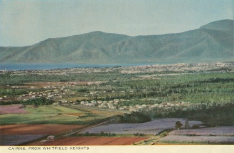
Between Stratford (on the Kuranda railway line) and Edgehill there is the Mount Whitfield Range. In 1973 the suburb of Whitfield was formally named, taking the western part of Edgehill. Mount Whitfield (364m) is north of the suburb in the Mount Whitfield conservation park. It was named in 1873 by George Dalrymple, explorer, after Edwin Whitfield, a merchant in Cardwell. Whitfield has a state primary school (1989).
Brinsmead, immediately west of Whitfield, was formally named in 1975 after the Brinsmead Gap in the Mount Whitfield Range. The gap is west of the intersection of Hillview Crescent and Fogarty Street. (Horace Brinsmead farmed land to the north-west at Freshwater and pioneered tourism in Cairns in the 1920s.) Brinsmead has local shops and the Cairns Christian College (1983).
WEST SUBURBS
Until 1970 the unbounded suburbs west of central Cairns were, moving outwards, Parramatta Park, West Cairns and Enmore. Part of Parramatta Park and all of West Cairns became:
Manoora, formally named in 1975 after MV Manoora (1935-72). The vessel was a prewar coastal trader and an armed merchant cruiser during the war. Manoora has a shopping plaza and a community centre.
Manunda: see separate entry.
Mooroobool: formally named in 1973 after Mooroobool Peak (625m) in the Whitfield Range, just west of the suburb. Mooroobool has a state primary school (1954).
Westcourt: formally named in 1973, taking the part of West Cairns between Gatton Street and the Bruce Highway. It has Westcourt Plaza shopping centre and two retirement villages.
Enmore's built-up area in 1970 was a handful of streets between Reservoir Road and Moodys Creek. Now almost completely subdivided, Enmore has been replaced by Manoora and Mooroobool (see above) and:
Kanimbla: formally named in 1989 by excision from Manoora and Mooroobool. MV Kanimbla was a coastal passenger vessel, wartime landing ship in the South West Pacific and a postwar tour ship in north Queensland. (Ship lovers can consult Peter Sherman's histories of the Kanimbla.)
SOUTH WEST SUBURBS
In 1970 Cairns' built-up suburbia ended at Woree, on the Bruce Highway and north of Gordon Creek. Bayview Heights, immediately west of Woree, was formally named in 1970. Urban development later crept toward the country town of White Rock, some 3 km south on the Bruce Highway. In 2001 the suburb of Mount Sheridan was formally named, lying south of Bayview Heights and west of White Rock. It was named after the peak in the southern Whitfield Range named by George Dalrymple in 1873 after Brinsley Sheridan, Police Magistrate in Cardwell. The peak (605m) has the headwaters of Gordon Creek, and is 4 km west of Woree. Mount Sheridan has a drive-in shopping centre on the Bruce Highway, diagonally opposite White Rock primary school, with a supermarket and 24 other outlets.
The census populations for these suburbs has been:
| area | population | |
|---|---|---|
| 2006 | 2011 | |
| Whitfield | 4219 | 4176 |
| Brinsmead | 5022 | 5234 |
| Manoora | 5616 | 5688 |
| Mooroobool | 6618 | 6815 |
| Westcourt | 3178 | 3906 |
| Kanimbla | 1909 | 2366 |
| Bayview Heights | 4090 | 4150 |
| Mount Sheridan | 7235 | 7994 |
Cairns entry