Cambooya, a rural town, is 20 km south-west of Toowoomba.
The area was settled by Arthur Hodgson in 1840. Hodgson chose 65,000 acres of choice land on eastern Darling Downs, fertile slopes watered by the headwaters of the Condamine River (Hodgson and Emu Creeks). He named his pastoral run 'Eton Vale'. The ruins of Eton Vale homestead, New England Highway, are listed on the Queensland heritage register.
In 1843 New South Wales Commissioner of Crown Lands, Christopher Rolleston, carried out a survey and reserved a site on Eton Vale for a township, lands administration facilities and a court house. He named it Cambooya, a rendering of the Aboriginal word 'yambuya', thought to refer to tubers growing in a water hole. Rolleston's township did not eventuate, however. Hodgson resisted the formation of a township and nearby Drayton instead emerged as the region's principal settlement.
Cambooya did become a railway station in 1868, however, when the line was extended from Toowoomba to Warwick, and this development, along with a simultaneous closer-settlement subdivision of part of Eton Vale, overcame Hodgson's resistance to a township.
Cambooya's main industry was the railway goods yard. A State primary school opened in 1882. In 1903 83 town allotments were sold and Cambooya was described in the 1903 Australian handbook:

By 1908 the town had two hotels, various shops and stores, a saleyard, Anglican and Presbyterian churches, two banks and a school of arts.
In 1914 Cambooya Shire (see separate entry) was created, with its offices in Greenmount. At about that time Cambooya achieved a population of over 600 people, a figure not reached again until the 1990s.
Cambooya had local competition from Greenmount as the shire's centre, and from Clifton as a district centre (secondary, of course, to the overwhelming dominance of Toowoomba).
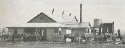
Paradoxically, it was Toowoomba's expansion, and rising house prices, that have created a demand for lower-cost sites and rural-residential living in surrounding areas such as Cambooya. The town's second growth phase began in the 1980s, and in 1990 it had a pre-school as well as the state primary school, a hotel, several local businesses including a soft drink factory, a public hall, bowls club, three churches and several sports groups. Reticulated water was laid on from deep aquifers in 1988, out of reach from waste-water seepage from the increasing numbers of houses. The railway goods yard by then lay virtually silent, but functioning grain silos continue to dominate the townscape.
The town ranked 23 in Australia for liveability by a BankWest survey in 2008 taking into account factors including employment, crime rates, health, earnings and community involvement.
Cambooya's census populations have been:
| Census Date | Population |
|---|---|
| 1881 | 56 |
| 1911 | 607 |
| 1954 | 343 |
| 1991 | 465 |
| 2001 | 711 |
| 2006 | 853 |
| 2011 | 1298 |
Rae Pennycuick, The Cambooya story, 1840-1990, Greenmount, Cambooya Shire Council, 1991
Ethne Hannaford, Cambooya State School centenary, Cambooya, Cambooya State School, 1982