Darra, an industrial and residential suburb, is 13 km south-west of central Brisbane. It is thought that the name was derived from an Aboriginal word referring to stones, or was inspired by Darra Hill, near Aberdeen in Scotland.
Situated on the Ipswich to Brisbane railway (1876), Darra was well beyond suburban Brisbane. It had been part of Stephen Simpson's Wolston Estate, administered from Wolston House (1853) in Wacol. Darra was described in the 1903 Australian handbook:

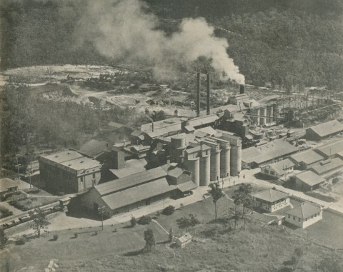
In 1914 a post office was opened at Darra and a primary school was built the following year. Two years later Queensland Cement Ltd began production at Darra on land north-west of the station. Brittains's brick works were started east of the station. In addition to farmers living further away, there were over 400 residents by 1921. Darra and the area extending to Jindalee were identified at the Second Australian Town Planning Conference in 1918 as the place for an 'industrial garden city'. It had access to coal (Ipswich), river, rail and port facilities and the cement and brick-making industries. The plan provided for noxious industries south-west of the town centre, a hospital and two grammar schools. When they came, 75 years later, the grammar schools were in Forest Lake, 4 km south. The Our Lady of Sacred Heart Catholic School was opened in 1937 (rebuilt in 1975, it is now the Darra-Jindalee Catholic primary school).
Local employment and low house and land prices encouraged people to move to Darra and by the mid-1950s the population exceeded 2500. The Cementco bowling club (on the cement works site) opened in 1949. In that year the post office directory recorded the Darra motorbus service, bricks, pipes and mosaic tiles made at Brittains, the Darra picture theatre and shops in Railway Parade, Anglican and Methodist churches and a Catholic church and primary school (1937). Further afield there were several poultry farmers. In 1950 the Boscrete factory was opened to supply building materials for the Housing Commission's Inala Estate.
The population grew markedly during the 1960s-70s. Darra was well located for industry and freight movement, particularly when the Centenary Highway was joined to Ipswich Road in the late 1960s. The basic standard postwar housing offered affordable prices and rent levels, and in the late 1980s there was a substantial Vietnamese community in Darra. Ten years later price levels moved sharply upward: Darra was no longer a fringe suburb, it was well located, and the general rise in metropolitan house prices saw Darra's grow by 50% during 2000-03. Scaling down of the cement works was followed by less annoying industries on the QCL site – freight centres and warehouses.
Darra has local shops near the railway station, State and Catholic primary schools, a soccer club, the Cementco bowling club, Anglican and Catholic churches, and the enduring Boral brickworks east of the housing area. The mosque of the Islamic Society of Darra (1983) was originally in Darra but later relocated to neighbouring Oxley. The Linh Son Buddhist Temple (1994) was built in Rowe Terrace. In Monier Street the boundary with Seventeen Mile Rocks, there are the Monier Hotel and the Centro Monier shopping centre.
Darra's census populations have been:
| area | Census Date | Population |
|---|---|---|
| Darra including Seventeen Mile Rocks and Jindalee |
1921 | 423 |
| 1947 | 1457 | |
| 1961 | 3485 | |
| 1971 | 5058 | |
| Darra only | 1976 | 3815 |
| 1991 | 4065 | |
| Darra including Sumner |
2001 | 3679 |
| Darra only | 2006 | 3814 |
| 2011 | 3838 |