Travelling west from the suburbs of Redbank Plains and Springfield there are several rural/residential localities south of the Cunningham Highway. Some are planned to become large suburbs by the 2030s, located in the area initially designated as Ripley Valley.
White Rock is immediately west of Springfield and Woogaroo Creek. It includes a large conservation area.
Swanbank is north-west of White Rock and adjoins the former Blackstone coalfields. Swanbank, along with South Ripley, Ripley and Deebing Heights, comprise the Ripley Valley urban growth area. The area's scope extends from near the Ipswich-Boonah Road to White Rock, and from the Cunningham Highway to near the Bundamba Creek lagoon. It is roughly bisected north-south by the Bundamba Creek, and west-east by a proposed South West Transport Corridor which is an extension of the Centenary Highway, Springfield. The plan is for 120,000 residents and 50,000 dwellings over 25 years.
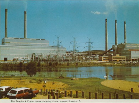
At present Swanbank has the remains of several collieries, a spur railway line and a power station. It was named by John Clarke Foote, partner in Ipswich's Cribb and Foote store (1849), after his wife's birth place in Scotland.
The power station's first generating unit was commissioned in 1966 and closed in 2002. Later units are coal and gas-fired, some of the gas being drawn from landfill site. In early 2014 Stanwell Power Corporation announced that the low-emission gas-fired Swanbank E power station would close for three years from October 2014 replaced by the coal-fired Tarong power station to meet electricity demands, as it had become more lucrative to sell the gas than burn it to produce electricity.
South Ripley encloses the headwaters of the Bundamba Creek, and Ripley lies north of it and extends to the Cunningham Highway. The origin of its name is apparently unrecorded and its original location was further south. Ripley has a small housing estate and rural/residential acreages. The Ipswich Region community church is in Ripley Road.
Hiscock's New District Atlas for Queensland (1878) showed Ripley as a small locality, just west of the Bundamba lagoon and five km north-east of Mount Goolman. A topographical map of 1972 shows Ripley as having moved north to midway between the Bundamba lagoon and the Swanbank power station. That area is now described as South Ripley.
The origin of the designation 'Ripley Valley' is also unclear. The district's valley is probably along Bundamba Creek, between the Grampians (west) and White Rock (east). 'Ripley Valley' lies north of these hills.
In 2013 the State government announced the building of a new primary school at Ripley Valley as part of 10 new schools to be built in high-growth areas under a private-public partnership model, with the private companies responsible for maintaining the school for up to 30 years.
Ripley's western boundary is Deebing Creek, and beyond it there is Deebing Heights. It is thought that Deebing was an Aboriginal expression describing a mosquito or winged insect. Deebing Heights has a small housing estate near the Cunningham Highway and rural/residential acreages. Just beyond Deebing Heights the South West Transport Corridor's proposed route joins the Cunningham Highway.
Further west there are Purga, Willowbank and Mutdapilly, rural areas described in separate entries.
Census populations have been:
| Locality | Population | |
|---|---|---|
| 2006 | 2011 | |
| Ripley | 878 | 1024 |
| South Ripley and Swanbank | 349 | 344 |
| Deebing Heights | 1158 | 1145 |
| Purga | 678 | 600 |
| Willowbank | 1170 | 1254 |
| Mutdapilly | 608 | 390 |
White Rock's population was included in the census area for Springfield.
Springfield entry