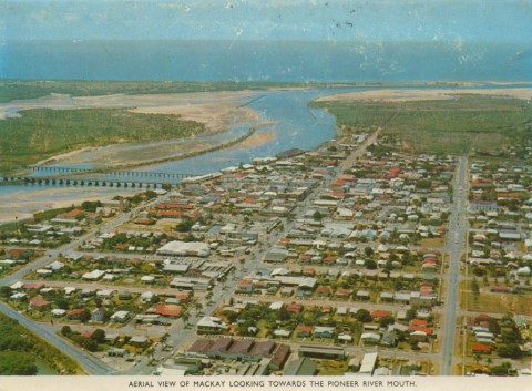
North Mackay, immediately across the Pioneer River from the central city area of Mackay, expanded from a few thousand people in 1950 to several suburbs by 2000. The main suburbs are Mount Pleasant, Andergrove, Beaconsfield and Glenella (see separate entries). Mackay Harbour to the east adjoins the outer harbour opened in 1939. North Mackay is ringed by these suburbs and was part of Pioneer Shire until the shire was amalgamated with Mackay City in 1994.
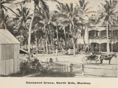
European settlement on the north side of the Pioneer River began in 1867 (five years after the town of Mackay was established) and was on the flood-prone northern bank known as Cremorne. John Barnes planted a tropical orchard alongside the European trees such as apple and peach, converting the landscape into a botanic garden. His hotel (1884-1958) and pleasure grounds were modelled on Cremorne Gardens, London. The linking of Cremorne to Mackay by an iron bridge (1888) greatly aided its accessibility, but there were plenty of empty building allotments on the south side. Beyond Cremorne the landscape rose and undulated, in contrast to the flat ground on which the Mackay township's grid had been laid out.
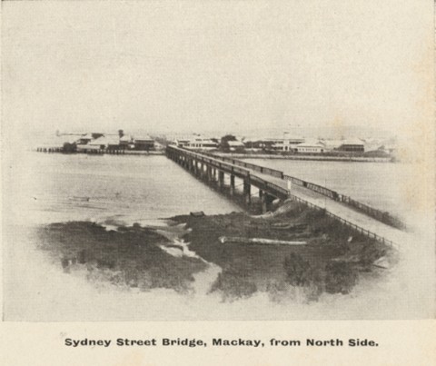
The 1921 census recorded 136 people in North Mackay, and the 1933 census 1211 people. A primary school was opened in 1915 and the North Side Progress Association was active in the 1920s. The Cremorne swimming pool tempted Mackay residents to cross the river. The construction of the outer harbour (1935-39) and the electrification of residential blocks just beyond the Sydney Street bridge, serviced by buses from the city, suburbanised North Mackay. Reticulated water was connected in 1942. The old iron, Sydney Street bridge was replaced by the concrete Forgan bridge in 1938, electrically lit with separate provision for pedestrian walkways and water-pipe conduits. There were two primary schools, North Mackay Primary (1915) and St Joseph's Catholic Primary (1936).
In the early post World War II years North Mackay was popular for cheap allotments and low rates. By the 1970s the elevated aspect near the new outer suburbs made the area a sought after location. As a developing area, North Mackay set the pace in changes to retailing. When North Mackay houses still had backyard chook runs and residents ran accounts with the general store in Malcolmson Street, the store's owners found that labour costs in the early 1950s were eroding their profits. In 1953 they converted to a self-service store, halving staff numbers. A short way east, on Harbour Road, a Big Bear drive-in shopping centre was opened in 1964. The sub-regional Mt Pleasant shopping centre was opened in 1981.
Mackay North State high school began in 1964, followed by the neighbouring Fitzgerald State primary school in 1979. The Mackay Christian College in North Mackay opened in 1984, and in Beaconsfield, Whitsunday Anglican College (1988) and in Mt Pleasant, Emmanuel primary school, added substantial non-state facilities to the north of the river. A swimming pool was opened in John Breen Park, a short way from the State primary school. A second bridge, named after the local state parliamentarian Ron Camm, was opened in 1980, linking Mt Pleasant to West Mackay via the Bruce Highway. The bridge is near the Mater Hospital. North of there, the Goosepond Creek is enclosed by a linear park and a large reserve with a swimming pool.
The Forgan bridge runs on to Harbour Road, which leads to two long ocean beaches and Slade Point.
North Mackay's census populations have been:
| Census Date | Population |
|---|---|
| 1921 | 136 |
| 1933 | 1211 |
| 1947 | 2149 |
| 1954 | 3534 |
| 1961 | 4602 |
| 2006 | 6367 |
| 2011 | 6597 |
K.H. Kennedy, Mackay revisited, Mackay, Mackay City Council, 2002
John Kerr, Pioneer pageant, Mackay, Pioneer Shire Council, 1980
Andergrove, Beaconsfield, Glenella and Mount Pleasant entries