Rocklea, an industrial and residential suburb, is nine km south of central Brisbane. It was named after the Rocky Water Holes, a watercourse that rises in the Toohey Forest Park in Nathan and enters the Oxley Creek near its junction with the Brisbane Golf Course.
Despite the industrial nature of present-day Rocklea, the land around the watercourse was good farming country. Regular flooding back up the Oxley Creek watershed provided frequent additions of surface loam. Settlement was evident with the licensing of the Crown Hotel in 1862, a Primitive Methodist church (1863), a post office (1866) and the Rocky Water Holes (later Rocklea) Hotel on Ipswich Road (1874).
The name Rocklea officially adopted in 1884 for the railway station, derived from the water holes and softened with 'lea', the old English word describing a meadow or piece of arable land. Rocklea became a dairying district, and there had been experimental silk production in the mid-1870s. The village, with two hotels, a school of arts, stores and a shire hall was clustered around Fairfield Road where it crosses the water holes.
The South Coast railway (1885) passed through Rocklea, and its opening coincided with the building of the Rocklea primary school. The railway enabled the Brisbane Golf Club to have a course laid out in 1904 at the northern edge of Rocklea within easy walking distance of the Yeerongpilly railway station. The Yeerongpilly shire, however, had its second offices in Annie Street, Rocklea, a matter of comment in the Australian handbook in 1903:

The local community, however, passed up the golf club, preferring the showground opened by the Rocklea Agriculture and Industrial Association (1917), a short way from the Rocklea railway station. A dog-coursing ground was near the showground. The Yeerongpilly shire offices became a Masonic temple after the shire was absorbed by Greater Brisbane Council.
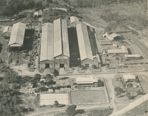
The railway did not bring many visitors to Rocklea's attractions, but in 1926 it was a factor in Evans Deakin building an engineering workshop. Fifteen years later there were munitions and armaments works at Rocklea, which in peacetime served as a basis for Brisbane's emerging manufacturing industry. Military bases were converted to housing and there was also a War Housing estate. From 10,000 dairy cows before World War II, only two dairy farms remained in 1965. But there were 2000 manufacturing workers employed by over 100 firms in the old munitions area.
Secondary industry and transport facilities marked out Rocklea's postwar development, but it did not entirely throw off its connection with primary industry. The State animal husbandry research station occupied a substantial area in the west of Rocklea until 2000. Part of this land along the creek has subsequently been turned into Oxley Creek Common, providing recreational green space for picnics, walking and canoeing, together with an environment centre. On the other side of Sherwood Road there is the Brisbane fruit and vegetable markets, transferred to there in 1964 when the Roma Street facility in Brisbane was closed. The road system, unable to cope with the market traffic, was widened, obliterating most of the old water holes village.
Church attendances have tended to be in neighbouring suburbs, and the sole remaining place of worship is the Russian Orthodox Church (1956). The annual Rocklea show continues at the showground and celebrated 91 years in May 2013. Harness racing also used the venue until folding in 2009. There are public reserves and a walking trail east of the old showground.
FLOODS 2011
Rocklea was Brisbane’s most flooded suburb in January 2011, as it was in 1974 and in 1893 when there was only a village and farms. It has come to be expected that open spaces along Rocky Waterholes, Stable Swamp and Oxley Creeks will go under with serious floods, together with the markets and many industrial sites. That leaves the residential areas from the railway line to Granard Road. In January 2011 very little of these were missed, and were the only part of Rocklea that stayed dry. Both the Australia Post mail centre and several freight tracking centres were rendered inoperable, delaying mail to most of Queensland and the dispatch of transport for rural re-supply in flooded areas.
Rocklea's census populations have been:
| Census Date | Population |
|---|---|
| 1911 | 248 |
| 1921 | 522 |
| 1954 | 244 |
| 1976 | 1892 |
| 1986 | 1607 |
| 2001 | 1459 |
| 2006 | 1500 |
| 2011 | 1255 |
Annie McKenzie, Memories along Boggo Track, Brisbane, Boolarong, 1992
Sunday Mail, 7 July 1929
Tapestry of time: a history of the Rocklea State School and the district, Rocklea, Centenary Committee of the Rocklea State School, 1995