Toombul, a residential locality of Brisbane, is nine km north-east of central Brisbane. Between 1883 and 1925 there was also Toombul Shire, an area of 72 sq km extending from Eagle Farm to Sandgate (but not including those places). It is thought that the name was an Aboriginal expression referring to a place with hoop pines.
In 1838, a short way east of Sandgate Road where it is crossed by Kedron Brook-Schulz Canal, a Moravian mission for Aborigines was established. Some of the mission's first members are buried in Nundah cemetery, Hedley Avenue. They were among Toombul's earliest permanent inhabitants and, co-incidentally, were in the present area of Toombul. The mission, known as Zion Hill and German Station, is generally associated with Nundah.
The Toombul local government division (1883) and shire included Nudgee where, in 1860, Thomas Childs began his Toombul vineyard, an enterprise that continued until the 1930s. Nudgee was an outlying fertile locality, for the most part surrounded by a coastal setting of swamp or mudflats stretching from Cabbage Tree Creek to the Brisbane River. The emerging seaside place for Brisbane's inhabitants was Sandgate, to where a railway was opened in 1882. Passing through German Station (Nundah) and Nudgee, the line offered possibilities for fresh settlement. A branch line from Eagle Junction to the Eagle Farm racecourse (also opening in 1882) offered a similar prospect. The next year the Toombul local government division was formed, stretching from Hamilton to Cabbage Tree Creek.
Hamilton was severed from the Toombul division in 1890, with the prospect of urban growth on its river bank location and an electric tram service (1899). Hamilton retained the division's hall and offices, and new Toombul offices were built on Sandgate Road, Nundah in 1892.
The district's principal urban and shopping centre developed around Nundah. Clayfield, with a tram line (1901) and a railway station, was a conveniently serviced residential area with Clayfield College for boys (1902). An ultimately more prestigious boys' college was opened in 1891 by the Christian Brothers at distant Nudgee, with a bushland setting and a swimming hole in the Nundah Creek.
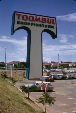
When its population was approaching 15,000 the Toombul Shire was incorporated into greater Brisbane Council (1925), and the place name was reduced to a railway station and little more. Nundah emerged as a dominant sub-regional shopping strip, until a piece of swampy ground east of the railway station and north of Schulz Canal caught the eye of the TC Beirne department store in 1959 as a possible site for a drive-in shopping centre. Beirne's was taken over by David Jones and the site lay undeveloped until acquired by Frank Lowy's Westfield corporation.
In 1967 Westfield's Toombul Shoppingtown opened. As well as becoming the region's largest drive-in shopping centre, Toombul is a large bus interchange. The Nundah shopping centre suffered the indignity of having a traffic tunnel put through it to relieve the traffic congestion on Sandgate Road.
Toombul Shire's census populations were:
| Census Date | Population |
|---|---|
| 1911 | 6791 |
| 1921 | 13,566 |
Nundah and Districts Historical Society, Old Toombul Shire, Ascot, The Society, 1989
Nundah entry