Auchenflower, an inner riverside suburb of Brisbane, is 3.5 km west of the CBD on Milton Road.
Originally part of the numerous rural estates surveyed from Milton to Toowong in the 1850s, the name 'Auchenflower' emerged about 30 years later. In 1876 a Brisbane ironmonger, John Ward, acquired a block rising from the river bank north-west to Milton Road, near the present Auchenflower railway station. On the highest level ground he built a substantial house with a view south-west to Mount Coot-tha. The house was sold to Thomas McIlwraith, Queensland Premier (1879-83) in 1880, who named it Auchenflower after the McIlwraith family estate in Ayrshire, Scotland. The Gaelic name is thought to describe a field of flowers.
GENTEEL ESTATES
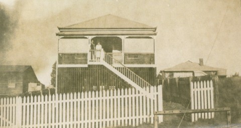
A substantial European settlement existed in the district by the time of McIlwraith's arrival. Ambrose Eldridge and Robert Cribb were two of the earlier settlers, constructing Milton House and Dunmore respectively in 1854, both of which proved too close to the river when the 1893 floods arrived. On higher ground Randall MacDonnell built Rathdonnell (c1905), not far from the Auchenflower Presbyterian Church (1913). The canny Scots imbued the suburb with middle-class thrift and respectability when their estates were subdivided for 16-32 perch house allotments.
Milton and Toowong were the early village centres (their schools opened in 1889 and 1879 respectively), and each had stations when the railway line opened in 1875. Auchenflower's station opened in 1887, by which time suburban housing development was under way. Nevertheless, there remained space for gracious Queenslanders: Moorlands, built by the Mayne family near the river in 1892 and Fairseat, Augustus Gregory's home, west of Rathdonnell.
The major floods of 1893 and 1974 tested the choices of Auchenflower house sites, before flood-mitigation measures implemented after 1974 took effect upstream on the Brisbane River.
URBANISATION
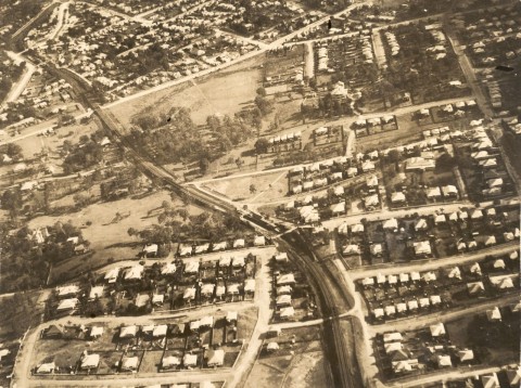
The subdivision of the Auchenflower estate (1903) anticipated the opening of the electric tram line along Milton Road the following year, and from 1900 to 1913 about 700 allotments in various estates were sold. Auchenflower became a commuter suburb, interspersed with vacant land and dairy agistments along River Road (or Coronation Drive, as it was renamed in 1937).
Auchenflower House was acquired for a Carmelite Monastery in 1927, and the site was cleared for construction of a church in 1967. Auchenflower House's ballroom and billiard room were re-built at Norman Park, the centerpiece of 'Early Street Historical Village', a colonially-themed tourist attraction. The rooms today can be found at Tamborine Estate Winery, in the Beaudesert Shire south-west of Brisbane, where they were moved in the 1990s. Moorlands was bequeathed by the Mayne family to the University of Queensland in 1940. Used for war purposes (1941-45), it later passed to Legacy, who used it to house war widows and orphans until 1971. In that year it was sold to the Uniting Church. The Wesley Hospital was built in the grounds behind the house and opened in 1977. Moorlands is on the Queensland heritage register.
INNER SUBURB
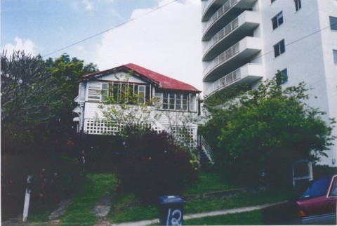
Auchenflower's colonial and prewar demography has changed. The Presbyterian and Methodist churches have been converted to a kindergarten and an Apostolic Church. The Chinese community, which once had market gardens in the suburb's lower lying areas, established a Chinese Club in 1957, but it closed in 1982. Numerous Queenslander houses have been replaced by units and apartments, all a short run by rail, bus or City Cat ferry (1996) from the city or the university. Commercial high-rise and office park developments have grown in recent decades, beginning with the Equitable Life building (1974), and extending down Coronation Drive from Milton. At the 2011 census 52.6% of Auchenflower's dwellings were flats, units or apartments.
Local shops are found along Milton Road near Munro Street but State schools are found outside Auchenflower, at Milton, Rainworth and Toowong.
Despite upstream flood mitigation, the flood in January 2011 invaded the old stream-bed tributaries of the Brisbane River. Moorlands Park and adjacent land succumbed yet again. Dunmore Park (and adjacent land in Milton) were similarly affected. During the devastating 1893 flood, waters rose over the rail lines at Auchenflower.
For census purposes, Auchenflower was counted as part of Toowong until 2001. Its census populations have been:
| census date | population |
|---|---|
| 2006 | 5085 |
| 2011 | 5352 |
John Pearn, Auchenflower - the suburb and the name, Herston, Amphion Press, 1997