Bundamba is a former coal mining area, 5 km east of Ipswich. The Bundamba coal field included the Welsh settler village of Blackstone immediately south of present day Bundamba. Each is now a recognisable suburb within the Ipswich City local government area, and each had its own primary school.
Although known for its coal industry, there were pre-existing activities in the area. Earliest was Aboriginal stone quarrying on the Bundamba Creek, and it is thought that the name 'Bundamba' derives from an Aboriginal expression referring to the local stone deposit. On the shoreline of the Bremer River north of River Road there existed a flour mill, boiling down works, brickworks and a wharf, begun by Joseph Fleming in 1852. Blackstone was apparently named after the Irish town of the same name.
Coal
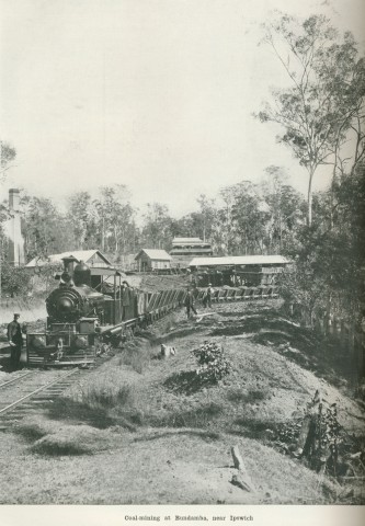
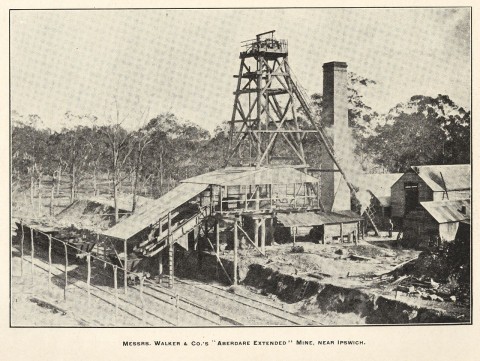
Coal was found south of the Blackstone township in 1866, the year after the Ipswich to Grandchester railway was opened. Lewis Thomas began the systematic mining of coal, initially in partnership with an Ipswich business person. The new railway provided a ready market for the commodity, while the steep terrain enabled tunnels to be driven into the hillsides. Thomas became the West Moreton coal king.
Welsh immigrants settled in the Blackstone township which Thomas in part created. He donated land for the United Welsh Church (1886) in Thomas Street, between Bundamba Creek and the railway line. The church was the venue for the first eisteddfod in 1887, the forerunner of an annual state-wide competition. Thomas' mansion 'Brynhyfryd' (1891) sat on a hilltop south of the primary school, in an area now pitted with mine shafts.
A loop railway (1904) from Redbank to Bundamba, itself attended by short branches, conveyed coal from the many collieries direct to the Ipswich wharf facilities on the Bremer River. In 1900 over three-quarters of the Ipswich coal came from Bundamba. The first station on the rail loop, south of Bundamba station, was for the Ipswich Racecourse, founded by the Ipswich Amateur Turf Club in 1890.
Culture and Amenities
In common with several districts around Ipswich, Bundamba Shire was separately constituted, although headquartered in Ipswich. It had an area of 38 sq miles (99 sq km) and 4332 persons in 1911. It was amalgamated with Purga, Brassall and Walloon Shires to form Moreton Shire in 1917.
Bundamba has a substantial residential area, and its northern boundary is the Bremer River. It has local shops, a high school (1970), a campus of the Ipswich College of TAFE, a primary school (1873), three churches and a public hall. Bundamba's civic centre is on Brisbane Road, east of the primary school. Notable elements are the war memorial reserve and the Uniting Church, a striking two-storey Methodist building (1911), which replaced a primitive Methodist Tabernacle built in 1865. Further east is Duce's joinery works and residence; Andrew Duce started the business in the 1930s after working at Kruger's sawmill (today the site of the TAFE).
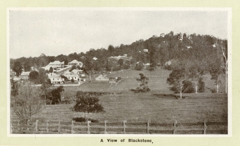
South of the joinery works is the Duce's Hill precinct. Several of its streets have well preserved domestic dwellings. The terrain rises to Bergins Hill which has water towers and a residential precinct associated with the collieries at neighbouring Blackstone. Blackstone has a smaller residential area, and is a substantially intact coal field town with Congregational and United Welsh churches.
The Congregational church (1879) at the corner of Mary and Thomas Streets is the earliest of several notable buildings. A short distance north-west are the Welsh church (1886) and an adjoining soccer field where Welsh miners first played in the mid-1880s. The United Welsh Church, one of only four in Australia, is on the Queensland heritage register and was the venue for the first Blackstone Eisteddfod in 1887. Numerous heritage houses can be found in Queen, Thomas and Mary Streets. Blackstone State School in Hill Street dates from 1887 and closed in 2009, despite a community campaign. The Blackstone-Ipswich Cambrian Choir, originally formed to contest the early eisteddfodau, continues the Welsh choral tradition to this day.
Floods 2011
Blackstone and Bundamba are on the Bundamba Creek, which is prone to flooding during downpours. At its northern (Bundamba) end the creek is adjoined by a flood plain which for the most part, has been avoided by built-up areas. Around where the creek crosses Brisbane Road planners have been less far-seeing. The State primary school and the racecourse were flooded in 2011. In Blackstone flooding mainly affected creek-side land and parks.
Census populations have been:
| census date | population | |
|---|---|---|
| Blackstone | Bundamba | |
| 1891 | 145 | |
| 1901 | 456 | 582 |
| 1933 | 735 | |
| 1947 | 600 | |
| 2006 | 837 | 5159 |
| 2011 | 1017 | 5404 |
A.H. Adams, Bundamba State School 1873-1973: centenary booklet, Bundamba, Bundamba State School, 1974
Geoff Ford, Ipswich potteries: 1873-1926, Ipswich, Ipswich Art Gallery, 2004
R.L. Whitmore, Coal in Queensland: from Federation to the twenties, 1900 to 1925, St Lucia, University of Queensland Press, 1991