LOCKYER VALLEY
The Lockyer Valley is a wide alluvial plain between Lowood and Gatton through which flows the Lockyer Creek. The creek's headwaters are at Mount Castle, west of Boonah, beginning as Laidley Creek until it is joined by Sandy Creek east of Gatton. Lockyer Creek then meanders north-easterly to join the Brisbane River about 5 km south of the Wivenhoe Dam. The creek was charted by Edmund Lockyer in 1826 when he navigated the Brisbane River 195 km upstream.
In addition to the Laidley and Sandy Creeks there are several other tributaries. From the south: Ma Ma, Tenthill and Flagstone Creeks; from the north: Alice, Buaraba and Murphys Creeks. They all drain a catchment of about 3000 sq km, nearly one quarter of the catchment of the Brisbane River. The catchment’s boundaries extend to Buaraba (north), New England Highway (west) and Main Ridge National Park (south).
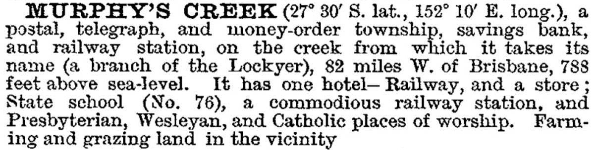
Murphys Creek was described in the 1903 Australian handbook:
FLOODS 2011
Since mid-December 2010 there had been rain storms, and the ground was saturated. On 10 January 2011 there was a massive downpour into the Lockyer catchment. By 12 noon Sandy Creek was rising fast and within two hours a flash flood poured through the village of Grantham on the junction of the Sandy and Lockyer Creeks. There was enormous loss of property and 22 deaths by drowning. At Helidon the flood gauge was over 4 metres above the major flood level at 3 pm. It was then swept away, and the level kept rising. The flash flood continued on its way to Brisbane.
Flood damage was also extensive at Murphys Creek and Withcott. It was estimated that 85% of bridges and culverts in the Lockyer Valley were washed away. At Gatton the Lockyer Creek rose 9 metres. ‘Lockyer Creek’ was a misnomer: it is a 100 km river.
In January 2011 the Grantham Butter Factory, representing the heart of the Lockyer Valley dairy industry which had closed in 1971 and remained idle, was put to use as a flood recovery and evacuation centre. In May 2011 the Rotary Club of Toowoomba South bought the solid brick building and a Rotary flood appeal and other sources raised more than $1.5m to restore and refurbish the building as a community centre. It was opened by Queensland Governor Penelope Wensley in June 2013.
The original butter factory had opened in Grantham in 1907 controlled by the Queensland Farmers' Co-operative Co Ltd. The foundation stone for the new brick factory was laid in early 1926 before the factory was opened by the Queensland Minister for Agriculture William Forgan-Smith in August 1926.
LOCKYER VALLEY REGIONAL COUNCIL
The Lockyer Valley Regional Council's area is shaped like a bunch of grapes and was formed in 2008 by the amalgamation of Gatton and Laidley shires. Gatton Shire comprised the western part, about two-thirds of the bunch, and Laidley Shire was the slender eastern one-third. Their areas were 1572 sq km and 701 sq km respectively. The Lockyer Valley Regional Council's western boundary is about eight km from central Toowoomba and the eastern boundary touches Grandchester. Its southern extremity is near Mount Castle and its northern boundary is near Lake Atkinson, the storage for Lockyer Valley irrigation.
Lockyer Valley Regional Council is crossed from east to west by the railway line from Ipswich to Toowoomba. This very early railway (1860s) also had a southerly branch (1911) to Laidley. Gatton and Laidley were both on the winding main road to Toowoomba, and also the railway line. There were substantial rural towns and villages off the railway, such as Forest Hill, Glenore Grove, Hatton Vale and Plainland. The last two had German-Lutheran farm populations.
The Warrego Highway by-passes Laidley and Gatton, but passes near or through Hatton Vale, Plainland and Glenore Grove. These areas have acquired rural/residential subdivisions, including newly named localities. Grouped together they and their populations comprise:
| Locality | Population | |
|---|---|---|
| 2006 | 2011 | |
| Glenore Grove | 1163 | 743 |
| Plainland | 1448 | 1672 |
| Brightview | 849 | 669 |
| Regency Downs | 1705 | 2097 |
| Hatton Vale | 1266 | 1138 |
There is a similar settlement pattern north-west of Laidley, towards Gatton:
| Locality | Population | |
|---|---|---|
| 2006 | 2011 | |
| Laidley | 2858 | 3518 |
| Laidley South | 543 | 421 |
| Laidley Heights | 1136 | 1405 |
| Forest Hill | 342 | 730 |
| Gatton | 6012 | 6869 |
Gatton is the municipal headquarters of the Lockyer Valley Regional Council.
Although flanked by the major shopping towns of Ipswich and Toowoomba, in the Lockyer Valley Regional Council the leading employment sector is agriculture. Mushroom and vegetable growing, mainly in the Lockyer and Laidley valleys, accounts for 5.5% of employment. The valleys, if not the salad bowl of Brisbane, are certainly among the leaders.
Lockyer Valley Regional Council's area is 2273 sq km and its census populations have been:
| census date | population |
|---|---|
| 2006 | 30,120 |
| 2011 | 34,954 |
Gatton and Laidley Shires entries
