Pimpama Island was the area east of Beenleigh and the Pacific Highway, bounded on the north by Logan River and on the south by Pimpama River. It extended to Moreton Bay and included the localities now known as Norwell, Woongoolba, Cabbage Tree Creek, Steiglitz and Jacobs Well. Pimpama is on the other (south) side of Pimpama River, and was not part of the island.
In addition to its watercourse boundaries, in wet seasons the island was almost cut off by lagoons and swamps.
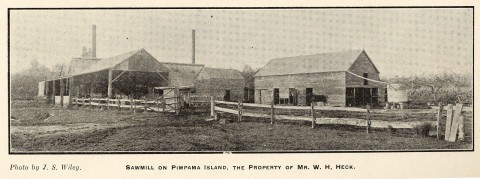
Pimpama Island was settled in the late 1860s and 1870s, mainly by German immigrants. A primary school was opened in 1876 on Stapylton-Jacobs Well Road, and Bethlehem Lutheran Church opened in 1882 about half a kilometre east of the school. Pimpama Island school of arts was opposite the school, along with a general store and a butchers shops. The Heck family's Rocky Point sugar mill was opened in 1879 about 1.5 km north of the school.
German-Lutheran settlement on the Island was quite intense, with Lutheran churches at Steiglitz and Norwell. They amalgamated with the Bethlehem church in 1959 and 1973. There is also a German Apostolic church in Norwell.
When the Island school was renamed Woongoolba the place name Pimpama Island began to fall out of use, although the community centre opposite the Woongoolba school is named 'Pimpama Island and Districts'. Pimpama Island's census populations were:
| 1921 | 1933 | 1947 | 2006 | 2011 | |
|---|---|---|---|---|---|
| Jacobs Well | 29 | 52 | 80 | 1201 | 1546 |
| Norwell | 213 | 222 | 203 | 487 | 282 |
| 'Pimpama Island' | 406 | 25 | - | - | - |
| Steiglitz | - | - | - | 583 | 441 |
| Woongoolba | 62 | 393 | 398 | 285 | 460 |
| 710 | 692 | 681 | 2556 | 2729 |
Jacobs Well, Pimpama and Steiglitz entries