Redbank, once a village and now an eastern suburb of Ipswich, is on the Brisbane to Ipswich railway line and is 22 km south-west of central Brisbane. It is close to the Brisbane River, opposite Moggill. The river bank's red soil inspired the name, although it is unclear as to whether the name was bestowed by the explorer Major Edmund Lockyer during his 1825 expedition, or later farm settlers.
The first European settlement in the Redbank/Redbank Plains area was a convict sheep farm established in the late 1820s. Free settlement was allowed from 1842, and farming settlers increasingly took up lots from the 1850s on the rich alluvial plains. Maize and potatoes were early crops, though cotton was grown in significant quantities through the 1850s and 1860s, as local farmers sought to exploit global shortages and a booming price occasioned by the American Civil War.
Coal
The first recorded coal mine in Queensland started at Redbank in 1843, and further activity followed in the late 1850s, with a small operation begun by partners John 'Tinker' Campbell and Robert Towns. In June 1861 disgruntled miners confronted Campbell seeking a pay rise; rebuffed, they went on Queensland's first strike. Nine years later flooding did permanently what industrial action had temporarily, closing the mine, despite claims that it contained further coal deposits. The site was reworked in the 1880s, and in 1910 Redbank Collieries was formed to exploit a site about 700 metres south of the Redbank railway station. A spur line transported coal to the Redbank railway-station junction (opened in 1874), which by then was a busy location with coal brought in from the Bundamba-Redbank railway loop (1904) built to carry coal from the better quality Bundamba, Blackstone and Aberdene coal fields. The Redbank Colliery employed 40 men (1916) but an explosion in 1928 and concerns about the quality of the coal led to the mine's closure in 1932.
Industrial Suburb
Redbank hosted a range of secondary industries. Campbell and Towns established a fellmongery and boiling-down works in 1857. The works were succeeded by meat chilling and freezing facilities (1897, 1900) with an abattoirs and a spur railway line (1912). The meatworks relocated to Brisbane, and John Morris acquired the site in 1931, converting the facility into a wool mill. The mill employed up to 900 workers at its peak and ran round the clock during World War II producing fabric and blankets. It closed during the 1980s. A less extensive site is Campbells Brickworks (1850s) in Mine Street, with a double-chambered kiln added by new owners in the 1930s.
During World War II Redbank hosted American troops and in late 1945 it was a dispersal centre for discharged Australian personnel. Postwar conditions stressed the cramped railways workshops in Ipswich, and in 1949 steps began to establish new workshops east of the woollen mill. Occupation of new buildings at Redbank began in 1958 but a further seven years passed before the railway foundry was operational.
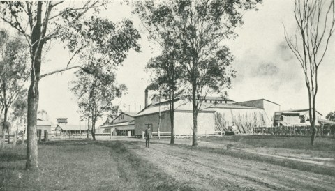
A 4000-tonne silo, constructed on Redbank’s industrial outskirts in the 1960s, was used to hold malt for beer brewing. After falling into disuse the silo was demolished by dynamite implosion in 2013 in order for the site to be cleared and restored to the ownership of Queensland Rail, which in 2012 completed building a railway stabling yard near the Redbank train station.
By the mid-1960s the expansion of urban Ipswich to Redbank was under way, beginning with the Greenacres estate. Several other estate subdivisions followed, contributing to the formation a new suburb, Collingwood Park, between Redbank and Redbank Plains. The new suburbs were separated from the shops around the railway station by the Ipswich motorway, and in 1985 the Redbank Plaza drive-in shopping centre opened. It has discount department stores and about 100 other shops. Redbank's older commercial and civic precinct is along Brisbane Road: the State primary school (opened in 1881, replacing an earlier Catholic school (1865)) the school of arts (1914) near Mine Street and the two-storey Commercial Hotel. The railway station and goods shed retain most of their original architecture.
A considerable amount of Redbank remains undeveloped, including the former rifle range (1912-80) east of Goodna Creek and south of the Ipswich Motorway. In 2013 contractors to the Department of Transport and Main Roads controversially bulldozed the heritage-listed rifle range wall. The Department began discussions to install a memorial on the site.
Floods 2011
With the Bremer River forming a semi-circle on its north and Goodna Creek flowing through it, Redbank had ample scope for flooding in January 2011. Water lapped the edges of the Railways workshops, but the Goodna Creek floodplain water ran over the Ipswich Motorway and south to Kruger Parade.
Redbank's census populations have been :
| Census Date | Population |
|---|---|
| 1881 | 19 |
| 1911 | 731 |
| 1933 | 428 |
| 1947 | 567 |
| 2006 | 1046 |
| 2011 | 1605 |
Until 2001 populations were recorded under a larger statistical area for eastern-Ipswich.
Ipswich City Council suburbs and placenames, 'Redbank'
Collingwood Park and Redbank Plains entries