Rosalie, formerly a residential suburb and now a locality of Paddington, is 3.5 km east of central Brisbane. Its suburban boundaries were approximately Fernberg Road, Haig Road, Thomas Street: and an irregular line leading to the western side of Government House (Fernberg). It is thought that the name came about from the owner of nearby Milton House, John McDougal, who owned the Rosalie Plains pastoral station (1864) and was at one time chairman of the Rosalie divisional board (Darling Downs). The change from suburb to locality occurred in 1975.
Rosalie was part of the land sales in the early 1860s in Paddington, creating several semi-rural estates. One of them was Fernberg (1865). A wetland extending from Baroona Road down through Milton to the Brisbane River attracted a few farms, and a wetland in Rosalie (now Gregory Park) was known as Red Jacket Swamp. The slightly higher area on the west of the swamp was used for the Milton primary school (1889).
In Rosalie itself a Baptist Mission church (1884) and post office (1889) were opened. More significantly, a tram service was run from Milton Road along Baroona Road to the school. A local kindergarten was opened in 1911. A few blocks north on Fernberg Road the Catholic Sacred Heart church and convent were rebuilt (1918, 1919), establishing the Church's strong presence in Paddington and Rosalie. A Marist Brothers college followed in 1929. There were also various nearby convent schools, the last being the Sisters of Mercy girls' school (1973). The Marist Brothers monastery and college (1929) are listed on the Queensland heritage register.
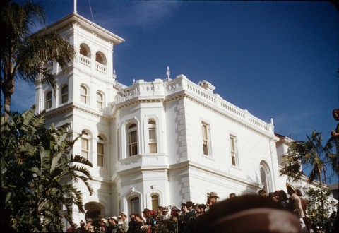
Fernberg was chosen as Government House in 1910, and in the next decade residential subdivisions extended beyond Fernberg toward Bardon and Rainworth. A motor bus service (1927) went from the tram terminus to Rainworth until the tramline was extended from Rosalie in 1930, running along Nash Street and past the school of arts and commemoration hall (1928), which later had the Beverley picture theatre, and the 'Little Citizens' kindergarten.
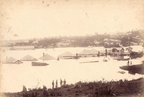
In 1893 much of Rosalie was flooded from the Brisbane River, backing up to Red Jacket Swamp and north of Fernberg Road. The 1974 event was nearly an exact replication. Queenslander houses avoided the worst, but southern style houses took weeks to dry out. The school of arts was used as a shelter for flood evacuees. It was later used by the Nash Street Theatre Company.
The Rosalie Village shopping centre is at the corner of Bardoona Road and Nash Street. In 1975 Rosalie was declared a neighbourhood in Paddington.
FLOODS 2011
In January 2011 flooding from the Brisbane River was a nearly perfect copy of the damage done in 1893 and 1974. Coursing though Dunmore and Gregory Parks, the floodwater went as far as the Rosalie shopping centre and further north to Fernberg Road.
A.T. Miles, A history of Rosalie, Eastwood, NSW, A.T. Miles, 1978