Rosalie Shire, an area of 2199 sq km on the Darling Downs, was amalgamated with Toowoomba City and six other shires in 2008 to form Toowoomba Regional Council. Its administrative centre was Goombungee, in the east of the shire and 120 km west of central Brisbane.
When the Rosalie Shire's area was first explored by Europeans much of it was grassed and lightly wooded, rising to the dividing range on the eastern border. Creeks were numerous, seldom reducing to less than waterholes during dry spells, making the area very attractive to pastoralists. The Rosalie Plains pastoral run along the Myall Creek was taken up in 1847.
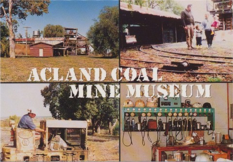
Substantial parts of the Shire were opened for farm selections in the late 1860s and the 1870s, often on uncleared scrub land. German settlers were numerous, practicing mixed farming and generally succeeding through self-sufficiency. The Rosalie local government division was proclaimed in 1879. Its southern border was serviced by the Toowoomba-Dalby railway (1868), but the northern part would be without a railway until 1913. During the mid-1890s the Toowoomba and Gowrie Junction Butter and Cheese factory began operation, a forerunner of the changeover to dairy farming in Rosalie Shire. By 1910 400 of the 1915 dairy farms on the Darling Downs were in Rosalie Shire. Within three years northern branch lines from the Toowoomba-Dalby railway were opened to Goombungee (1910) and Cooyar (1913), and a separate line through Yarraman in the far north was opened in 1913. Marketing was thereby assured, with production coming from over fifteen butter and cheese factories by the mid-1920s in Rosalie Shire. The main setback to the dairy industry was prickly pear infestation which by 1923 affected most of the shire except some southern parts. It was not fully cleared by the use of a parasitic moth until 1932.
Dairying achieved a peak production level when Rosalie Shire was described in 1946 in the Australian Blue Book:
The postwar decade saw the beginning of the decline of dairying and small farm holdings. Some farmers were reaching retirement and tried renting to share farmers, usually with little success: share farmers tended to prefer short-term exploitation, and mechanisation encouraged the removal of remnant tree cover and unwise land practices. Half the Shire showed signs of soil erosion, and stabilisation was sometimes achieved through elderly farmers letting Lantana grow unchecked. There was a swing to less intensive beef production. Four dairy factories remained by 1970, one surviving into the next decade. In 1993 the Shire had nearly 60,000 beef cattle and 20,000 dairy cattle. Grain, legumes and other crops occupied 41,000 ha.
The southern branch railway lines closed, the Goombungee line (1964), Acland to Cooyar (1964) and Oakey to Acland (1969). The decade reflected a similar decline in population: there had been a gradual decline throughout the period 1911-1961, but 1961-1971 saw it fall from about 6200 to 4800. The 1980s saw a rapid increase as rural/residential lifestyles spilled over from Toowoomba. Kingsthorpe was a case in point, with 208 people in 1961 and 1427 in 2001. Goombungee's population doubled to over 650 between 1961 and 2001.
Rosalie Shire's census populations were:
| Census Date | Population |
|---|---|
| 1911 | 7982 |
| 1947 | 6716 |
| 1961 | 6190 |
| 1981 | 5216 |
| 2001 | 8373 |
| 2006 | 9035 |
Diana Beal, Rosalie Shire Council - the first hundred years, Queensland, The Council, 1979
Diana Beal, The making of Rosalie: a history of the development of the modern landscape of the Darling Downs portion of Rosalie Shire from the 1840s, Toowoomba, Land Use Study Centre, University of Southern Queensland, 1993
Karen Handford, The history of Goombungee and District, S.l., K. Handford, 2003
Goombungee, Gowrie Junction, Jondaryan, Kingsthorpe and Yarraman entries