Stafford, a post World War II residential suburb, is eight km north of central Brisbane. Its southern border is Kedron Brook and the north is bordered by Stafford Heights, along a line running either way from Stafford Heights primary school.
Originally known as Happy Valley, the district was noted for agistment, dairying, noxious trades and extractive industries with Chinese market gardens beginning in 1857. Access between Brisbane and Happy Valley improved in 1870 when the Blackall bridge was built on Webster Road to cross Kedron Brook. Proximity to the brook led to tanneries, a wool scour, dairies and a fellmongery (for processing sheep skins, whereby flesh particles were removed by maggots). A quarry and brickworks were also operative by the 1880s, and it is supposed that the association of Stafford, UK with clay products may have inspired the change of name of the district. In any event, in 1886 when the post office and a school in Collier Street were opened, they were named Stafford, and Happy Valley Road was named Stafford Road.
Stafford was decidedly rural and industrial, a convenient agistment area for livestock destined for the Newmarket saleyards (1877-1931), driven down Enoggera or Grange Roads. By 1896 there was a local deputation about the pollution of Kedron Brook.
In 1925 there was further rural employment with the opening of a Council quarry, and the population of a few hundred attracted the attention of the Church of England in Lutwyche which moved two Army huts to a site named St Clements on the Hill in Eudunda Street. Around the primary school is the area which constituted Stafford's civic precinct, with a Methodist church also near the school.
Further west is Sparkes Hill, which was chosen as a site for a service reservoir in 1939, ultimately having four reservoirs by 1981. In 1940 a branch tramline from Lutwyche Road was opened to a terminus in Stafford Road near Clifford Street. Just after the war the Queensland Housing Commission built a housing estate near the terminus around Lutana and Buddina Streets, with a park at its centre. Any hoped-for garden city did not eventuate, with austerity-standard houses and an unkempt park, but in 1965 the park was improved and named after the local hero Keith Payne, one of four Australian winners of the Victoria Cross in Vietnam.
In 1948-49 a substantial three-storey brick State-primary school was built on a new site in Stafford Road. Designed by the Public Works Department in a somewhat severe interwar design, ageing and tree-planting have softened its looks. It is listed on the Queensland heritage register.
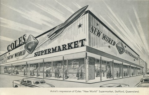
A shopping centre rapidly grew around the tram terminus during the early 1950s, with a baker, a butcher, shoe repairer, fuel merchant, newsagent and several mixed businesses. A large picture theatre, the Topic, was opened in 1957. The theatre lasted only a few years with the infatuation with newly-arrived television, and was converted to a Barry and Roberts self-service grocery store in the 1960s.
The Catholic Church built the Queen of Apostles church in Appleby Road (1957) along with a convent school a few years later. It was replaced with a larger, contemporary building in 1987, responding to a local Catholic population that made Stafford the largest parish communion in Queensland. The St Clements army huts had been replaced in 1979, also with a building of contemporary design.
Stafford's population grew rapidly from 832 in 1947 to over 20,000 in 1971 (including Stafford Heights and Everton Park). Such a population catchment proved irresistible to shopping centre developers, and in 1984 Gibson's tannery site in Stafford Road became the Stafford City drive-in shopping centre. It has 19,000 sq metres of space, with a discount department store and 60 other shops.
Gibsons was the last of a long series of industries displaced by housing. Most went in the 1960s, including the Brisbane City Council's quarry (1925-63) in Broughton Street in neighbouring Kedron. By then housing had spread northwards into the new suburb of Stafford Heights.
Kedron Brook enters the flood plain at the Brisbane Airport, where water flow stagnated rather than scoured. Pollution of the stream was a continuing problem, although flood-plain works have improved the discharge. In 1988 a bikeway was opened, from Sparkes Hill in the west and Hickey Park at the other end.
Stafford's census populations have been:
| Area | Census Date | Population |
|---|---|---|
| Stafford (including Everton Park and Stafford Heights) | 1921 | 213 |
| 1947 | 832 | |
| 1954 | 5460 | |
| 1961 | 12,467 | |
| 1966 | 17,692 | |
| 1971 | 20,834 | |
| Stafford | 1976 | 7303 |
| 1986 | 6158 | |
| 2001 | 5457 | |
| 2006 | 5513 | |
| 2011 | 6041 |
Everton Park and Stafford Heights each became a separate census district in 1976.
Barry Shaw, Stafford and Wilston-Grange heritage tour, Kelvin Grove, Brisbane History Group, 1995