Widgee Shire, abolished in 1993 following a merger with Gympie City, extended south-westerly from the Cooloola Coast, touching the boundaries of the Noosa and Maroochy Shires. It surrounded the separate Gympie municipality entirely. The name is thought to have derived from an Aboriginal word meaning red cedar, which was extensively harvested from the upper reaches of the Mary River valley, through Kenilworth, Imbil, Kandunga and Amamoor.
The Shire began as the Widgee local government division in 1879, including the subsequent shire of Kilkivan (severed 1888) and part of Noosa Shire (severed 1909). It excluded Gympie and its adjoining Glastonbury goldfield division, although Glastonbury was subsequently added to Widgee.
The Shire comprised much impenetrable scrub and had rich timber reserves in the Mary River area, and by the 1850s coastal timber cutting was underway and pastoral runs taken up. Several pastoral runs were consolidated into the Widgee Station, the district's largest and most successful.
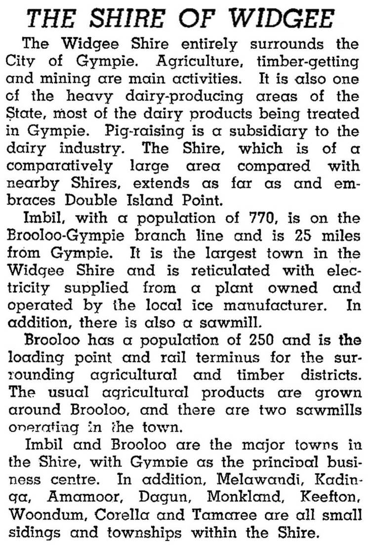
Gold discovery at Gympie in 1867 resulted in fossickers working up the river valley to Imbil, where alluvial gold was found. So, too, was timber and farm land. The railway line through Gympie (1889) provided improved access to southern markets, and timber was also cut in the east of the shire at Goomboorian and Wolvi. The Mary Valley railway was opened from Gympie to Imbil (1914) and Brooloo (1915). Banana growing also emerged during the 1920s, although disease later curtailed production. In 1946, when the population was about 8000, Widgee Shire was described as follows in the Australian Blue Book:
During the 1960s-70s the shire's population fell as timber reserves declined and the industry was mechanised. Dairying, beef cattle, fruit and vegetable growing were maintained in the Mary Valley, and deer grazing for venison was later introduced. It was away to the east that population grew, in land formerly thought to be second class: sand-mining on the Cooloola Coast led to the establishment of Rainbow Beach and prawn fishing in Tin Can inlet provoked a population surge in Tin Can Bay township. Cooloola Village, also on the Tin Can inlet, was later developed.
Widgee Shire's administrative centre was always in Gympie, and in 1993 the two local government areas amalgamated to form Cooloola Shire.
Widgee Shire's census populations were:
| Census Date | Population |
|---|---|
| 1911 | 4395 |
| 1933 | 8686 |
| 1961 | 7948 |
| 1971 | 6959 |
| 1981 | 11,317 |
Cooloola Shire Library Service, Cooloola Shire ... a golden past, Gympie, Cooloola Shire Council, 2001
Ian Pedley, Winds of change: one hundred years in the Widgee Shire, Gympie, Gympie Times, 1979
Cooloola Shire, Cooloola Cove, Gympie, Imbil, Kandanga, Rainbow Beach, Tin Can Bay and Traveston entries