Woongarra Shire (1885-1994), an area of 731 sq km, adjoined the southern and eastern sides of Bundaberg, the eastern part including the coastal towns of Elliott Heads, Bargara and Burnett Heads. Both the Burnett and the Elliott Rivers, important sources for irrigation, run through the former Shire.
The Burnett River area was taken up by pastoral leaseholders in the 1850s, and in 1863 a 'Wongarra' pastoral leasehold was mentioned as having been tendered for. Its boundaries were found to badly overlap with another leasehold and the name was expunged, but it appears to be the earliest suggestion of the name of the future shire. 'Wongarra' was linked with another leasehold in 1863, 'Barolin', which was the name of the first local government division formed in 1880. One of its sectors was named Woongarra, and in five years that sector was severed, thus forming the Woongarra division. It included the populous cane lands which had been cut from the fertile 'Woongarra scrub' east of Bundaberg.
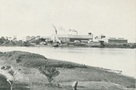
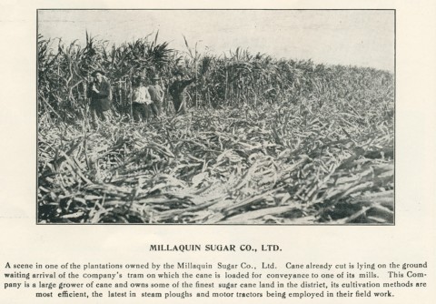
The Woongarra scrub was a tangle of vines and under-valued forest timber. The soil could be cultivated around the stumps, and its fertility yielded two maize crops a year. By the mid 1870s maize prices had fallen disastrously low, and farmers changed to sugar. By 1880 there were six small juice mills operating around Bundaberg, and in 1882 the Millaquin refinery in Bundaberg was opened, ensuring a ready outlet for Woongarra's cane farmers. The Qunaba refinery near Bargara, close to the future railway line, opened in 1900. It was the only large facility in Woongarra Shire.
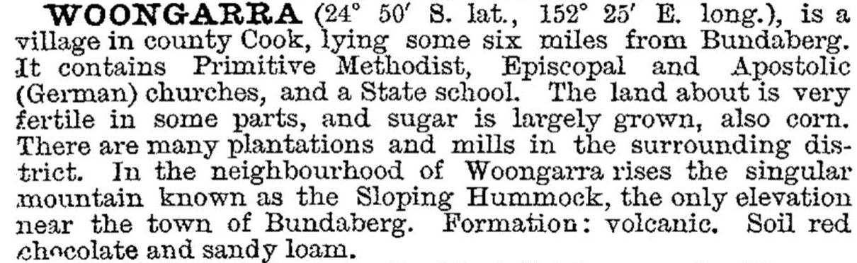
The town of Woongarra was described in the 1903 Australian handbook:
Railways were opened west and east of Bundaberg in the 1880s, to the Mount Perry mining district, beyond Woongarra division's western boundary, and to the eastern cane fields to carry sugar to the Millaquin refinery. The eastern line had been promoted by seaside land developers at Bargara and Burnett Heads. Those infant resorts had to wait another thirty years and then it was Bargara which obtained the extended railway line (1913).
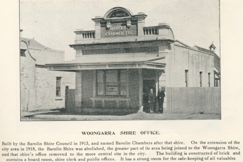
Woongarra Shire (1904) had Barolin Shire to its west. Protracted negotiations during 1908-18 led to Woongarra yielding its east Bundaberg territory to the Bundaberg town council, and later acquiring part and then the remainder of Barolin Shire.
Sugar cane growing dominated agriculture, although in years of low rainfall there were poor crops. Irrigation was experimented with and a weir was constructed on the Burnett River at Bingera in 1932. Further work awaited postwar reconstruction. Woongarra Shire, meanwhile, was described in 1946 in the Australian Blue Book:
Local fruit and vegetable growing was increased during the World War II to feed Australian and American troops stationed in Queensland. In 1946 Bundaberg and district formed an irrigation committee and in 1948 formed a fruit and vegetable growers association. Aquifers were tapped and good results obtained in the 1950s. Water pumped from rivers, aquifers, mechanisation and high postwar sugar prices produced unprecedented farm prosperity. The big irrigation projects - a salt water barrage on the Burnett River, the Monduran storage on the Kolan River's headwaters and a supply channel to Woongarra's farms - were completed in the 1970s. When sugar prices fell in the 1980s farmers moved to vegetable and fruit production, chiefly tomatoes. By 1993 field crops exceeded sugar cane in area throughout Woongarra Shire.
In 1994 most of Woongarra Shire was incorporated into Burnett Shire (see separate entry). Wongarra Shire's census populations were:
| Census Date | Population |
|---|---|
| 1911 | 2588 |
| 1933 | 3287 |
| 1961 | 4189 |
| 1976 | 8791 |
| 1986 | 11,915 |
| 1991 | 16,491 |
Ninety percent of the population in 1991 resided in the coastal towns and on the fringe of Bundaberg.
Neville Rackemann, The Growing Harvest: Bundaberg district fruit & vegetable industry from 1867, 1987
Neville Rackemann, A Century of Progress: Woongarra Shire 1885-1985, Bundaberg, Woongarra Shire Council, 1985
Bargara, Burnett Heads, Coral Cove, Elliott Heads, Innes Park and Moore Park entries