BUNDABERG NORTH
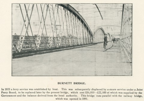
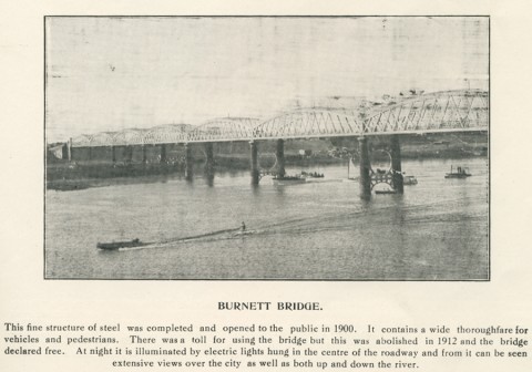
Bundaberg North, on the north side of the Burnett River, was the place where Bundaberg's European settlement began. Its early history is outlined in the entry on Bundaberg. Until the construction of a railway bridge over the river in 1890-91 communication between the two towns was by ferry crossing. The opening of the railway also provided for a pedestrian walk way on the bridge.
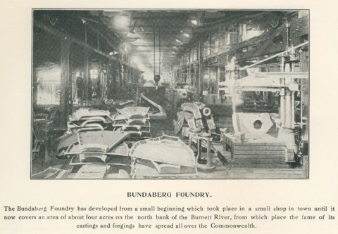
A school was opened at North Bundaberg in 1875. In 1901 the census recorded a population of 842. The Bundaberg Foundry opened there in 1885 and in 1907 first employed the future world aviator, Bert Hinkler. He was later commemorated in the Hinkler Museum in the Botanic Gardens, a short distance north of the foundry in Gavin Street. The Gardens are also home to a historical museum and the Fairymead sugar museum.
Bundaberg North was described in 1903 in the Australian Handbook:

In addition to the primary school (1875), Bundaberg North has a high school, local shopping, motels and a golf course.
Bundaberg North's census population has been:
| census date | population |
|---|---|
| 2011 | 5484 |
SUBURBS WEST OF THE RAILWAY
Bundaberg West is immediately west of the railway and includes the Bundaberg showground, two hospitals, an athletics and cycle track and several hotels along the Isis Highway. Along the Burnett riverbank there are public reserves and a zoo. Its primary school opened in 1926.
Further west there are Millbank, Avoca and Branyan. Avoca includes the Sugarland drive-in shopping centre, a retirement village, the Hinkler airport, a campus of the Central Queensland University, a state primary school (1980) and several recreation reserves. Branyan State primary school, near the Burnett River was opened in 1905. South of these are Svensson Heights, Norville and Kensington. Norville has a state primary school (1971) and the Shalom Catholic College (1984). Hinkler airport is in Kensington. In the early 2000s, light industry began to fill the area between residential suburbs and the airport.
The 2011 census populations for these areas were:
| area | population |
|---|---|
| Bundaberg West | 2529 |
| Millbank | 2601 |
| Avoca | 5045 |
| Branyan | 3339 |
| Svensson Heights | 3204 |
| Norville | 2556 |
| Kensington | 546 |
SUBURBS EAST OF THE RAILWAY
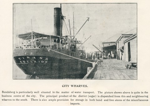
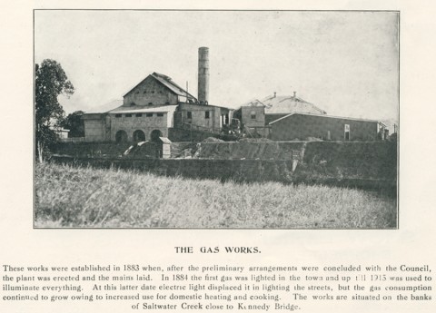
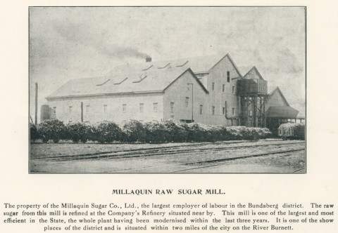
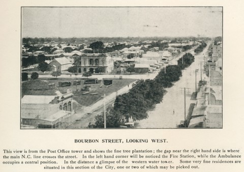
Bundaberg East is reached by Kennedy Bridge (1899) across Bundaberg Creek, leading to Bourbong Street East. The first bridge was built in 1878, enabling several industries to be established there near the river's wharves. They included timber yards, the Millaquin sugar refinery (1882), the Bundaberg gas works (1884) and the rum distillery (1888). Soon after crossing the bridge there is a heritage-listed landmark, an eight-level water tower. Bundaberg East's primary school was opened 1886 for children of workers who lived close to their employment. In 1903 Bundaberg East was described in the Australian Handbook:

South and south-east Bundaberg were settled after Bundaberg East: Bundaberg South school was opened in 1891. There is an extensive park and wetland along Bundaberg Creek. Further south are Walkervale, Kepnock, Avenell Heights and Thabeban. Walkervale State primary school was opened in 1955 and Kepnock high school in 1964. South of Avenell Heights is Thabeban, with an early State primary school (1917) and St Mary's Catholic primary school (1952). The Bundaberg racecourse is in Avenell Heights.
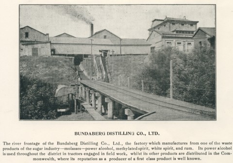
Bundaberg East follows the northerly direction of the Burnett River, and includes the site of the Bundaberg Distillery on the river's shoreline. The Anglican St Luke's secondary school (1994) and an aged care facility are just outside Bundaberg East, in Kalkie, which was once an outlying village. Kalkie primary school (1878) is on the Queensland heritage register.
The 2011 census populations for these areas were:
| area | population |
|---|---|
| Bundaberg East | 2810 |
| Walkervale | 3002 |
| Kepnock | 4533 |
| Avenell Heights | 5164 |
| Thabeban | 2827 |
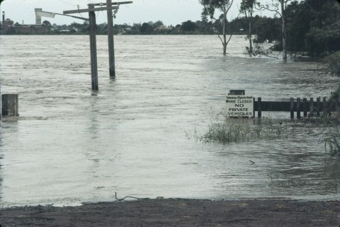
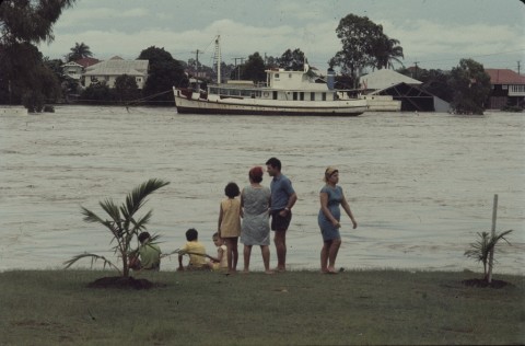
FLOODS 2011 and 2013
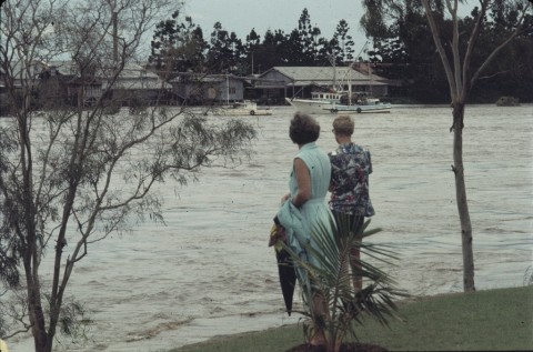
In late December 2010 the Burnett River rose to a 7.92 metre flood level, and by the new year water from the Bundaberg Creek and the water way east of the sugar mill had invaded Bundaberg East. Several houses adjacent to the water ways were flooded. Bundaberg South and Kepnock were also affected.
In Bundaberg North there was flooding of riverside areas and parklands around the primary school.
On the southern riverbank, Queens Park in Bundaberg West flooded, along with the undeveloped part of Millbank and parts of Avoca.
In January 2013 ex-tropical cyclone Oswald caused floodwaters which destroyed a number of homes in Bundaberg suburbs with over 2000 with water over their floorboards. North Bundaberg was left with no power, water or sewerage, and roads with gapping sink-holes. Residents had been evacuated and were let back in to the suburb on a restricted basis for a number of days. Floodwaters approached the Bundaberg Rum Distillery in East Bundaberg.
Enid Joy Cullen, A history of the 20th century in the Burnett, Bundaberg, E.J. Cullen, 2000
Janette Nolan, Bundaberg history and people, St Lucia, University of Queensland Press, 1978
John Y. Walker, The history of Bundaberg, (1890), facsimile 1977
History of Bundaberg and districts, Bundaberg, Bundaberg and District Historical and Museum Society, 1989, p 48
Neville Rackemann, Bundaberg from pioneers to prosperity, Bundaberg, Bundaberg City Council, 1992